
( Image from the Glen McLaughlin Map / December 17, 2012 )
In Volume II of the Encyclopædia Britannica published in 1768, the entry for California reads:
CALLIFORNIA, a large country of the West Indies, lying between 116° and 138° W. long. and between 23° and 46° N lat. It is uncertain whether it be a peninsula or an island.
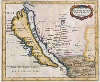
For well over a century California was believed by many to be an island. Maps drawn by the most learned cartographers showed it separated from the mainland by the Mare Vermiglio, or Red Sea. In 1971, maps of California as an island caught the attention of Glen McLaughlin, an American businessman, who began researching and collecting them. Over 40 years his grew to be the largest private collection of such maps. In a part donation and part sale, McLaughlin has now turned over the collection to to to Stanford University’s Branner earth sciences library.
A collection that identifies California as a world apart
The collection shows “layer upon layer of history,” said Julie Sweetkind-Singer, a Stanford map librarian. “It shows the perceptions of the times and the idea of exploration and finding new worlds.” In their day, the maps excited people the way images from the Hubble Space Telescope do today, she added.
Among the first to study the maps intensively will be author and geography expert Rebecca Solnit, whose 2010 book, “Infinite City: A San Francisco Atlas,” mapped that city for such things as Native American place names, contemporary murders and coffeehouses. She soon will start a six-month fellowship at Stanford with the goal of writing a book based on the McLaughlin collection.
Although the maps are technically wrong, their symbolism remains powerful, she said.
“California is not an island and doesn’t have an east coast and no Vermilion Sea. But it is so separate from other parts of the United States, economically, culturally and even spatially,” Solnit said. With mountains and deserts isolating California, and its agriculture, high-tech and entertainment industries so well developed, “who’s to say we are not this magical, amazing place?”
The maps, she added, “show this weird kind of dance between imagination and desire on the one hand and exploration and fact on the other.”
I’ve seen one of these maps before. I study maps sometimes when I’m bored.
I always thought it was an inland sea from a time before man, as it turns out, archaeologist and geologist know it as The Great Valley of California. Map: http://geoimages.berkeley.edu/GeoImages/BainCalif/CalClickMap.html
It was once a swamp way back then and not the rich farm land it is today, so that may explain why the old maps were drawn that way?
Then again, they may have been standing in Mexico and looking across The Gulf of California into what is now Baja California in Mexico?
Here is a photo of Young Marine Fossils (clam shells) in the Central Valley
Geology of California’s Great Central Valley.Recent uplifts in the western Great Valley expose fossils from the days when global sea level was higher. This Pleistocene shell hash is in a roadcut in the Kettleman Hills.
http://geology.about.com/od/geology_ca/ig/California-Central-Valley/shellsket.htm
Some of these maps may be seen at the Map and Atlas Museum in La Jolla, CA: http://mamlj.org/
Historical maps are fascinating-I hadn’t heard about this before. Do most West Coast or California residents know about this?