
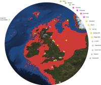
Doggerland, in red
What is the plural of Atlantis? Atlanti? Atlantises? Recently two different underwater areas have been in the news, both of which are referred to as “Britain’s Atlantis.” One is called Doggerland, a huge undersea region swallowed by the sea around 6500 BC, while the other is the the lost medieval town of Dunwich, which slipped into the ocean progressively between 1286 and the turn of the twenty-first century.
Each is fascinating in its own right. I only wonder whether Atlantis is the right designation, however. Atlantis was, after all, the legendary island from in Plato’s dialogues Timaeus and Critias, written about 360 BC. Atlantis was a great naval power lying “in front of the Pillars of Hercules” which sank into the ocean “in a single day and night of misfortune”. The two designated British sites given the appellation Atlantis each took far longer to sink. Perhaps, however, considering the full span of history, the difference is not so important.
Doggerland – when Britain was not an island
A recent article in the Mail-Online describes how divers from oil companies have found remains of a ‘drowned world’ with a population of tens of thousands. Doggerland, as it has been nicknamed, was a huge area of dry land that stretched from Scotland to Denmark and was slowly submerged by water between 18,000 BC and 5,500 BC. During this period, Britain and Ireland were part of a huge European peninsula.
The research suggests that the populations of these drowned lands could have been tens of thousands, living in an area that stretched from Northern Scotland across to Denmark and down the English Channel as far as the Channel Islands. The area was once the ‘real heartland’ of Europe and was hit by ‘a devastating tsunami’, the researchers claim. The wave was part of a larger process that submerged the low-lying area over the course of thousands of years.
‘The name was coined for Dogger Bank, but it applies to any of several periods when the North Sea was land,’ says Richard Bates of the University of St Andrews. ‘Around 20,000 years ago, there was a ‘maximum’ – although part of this area would have been covered with ice. When the ice melted, more land was revealed – but the sea level also rose.
Britain’s Other Atlantis – Dunwich, the Incredible sinking town

A 3D visualisation of the Chapel of St Katherine. Image Credit: University of Southampton.
On a much smaller and younger scale we have the the lost medieval town of Dunwich, which was once a thriving port – similar in size to 14th Century London. Over a period of seven centuries, coastal erosion and flooding from extreme storms almost completely wiped out the once prosperous town. As reported by EarthSky, Professor David Sear, a University of Southampton professor, has carried out the most detailed analysis ever of the archaeological remains of the lost town.
Secret streets of Britain’s Atlantis are revealed
[Professor Sear] comments, “Visibility under the water at Dunwich is very poor due to the muddy water. This has limited the exploration of the site.
“We have now dived on the site using high resolution DIDSON™ acoustic imaging to examine the ruins on the seabed – a first use of this technology for non-wreck marine archaeology.
“DIDSON technology is rather like shining a torch onto the seabed, only using sound instead of light. The data produced helps us to not only see the ruins, but also understand more about how they interact with the tidal currents and sea bed.”
Peter Murphy, English Heritage’s coastal survey expert who is currently completing a national assessment of coastal heritage assets in England, says: “The loss of most of the medieval town of Dunwich over the last few hundred years – one of the most important English ports in the Middle Ages – is part of a long process that is likely to result in more losses in the future. Everyone was surprised, though, by how much of the eroded town still survives under the sea and is identifiable.
“Whilst we cannot stop the forces of nature, we can ensure what is significant is recorded and our knowledge and memory of a place doesn’t get lost forever. Professor Sear and his team have developed techniques that will be valuable to understanding submerged and eroded terrestrial sites elsewhere.”
Thanks to Alaric Bond for contributing to this post.
fascinating stuff, great post, Rick! thanks!
This was on PBC (NOVA) a few years back, showing how early humans were living on the land between Western Europe and the UK back then.
Then again, it could have been on Nat. Geo or one of the other science type shows.
Yep, it was on Nat Geo: “Stone Age Atlantis”
http://natgeotv.com/uk/stone-age-atlantis/about
Here is the main page:
“Searching for Doggerland”
http://ngm.nationalgeographic.com/2012/12/doggerland/spinney-text