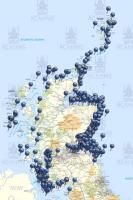
 The Royal Commission on the Ancient and Historical Monuments of Scotland (RCAHMS) has published a remarkable and potentially dangerous interactive map of 1,200 years of shipwrecks in Scottish waters. The map is part of an effort to enhance the maritime record for Scotland. Why is the map dangerous? Because it is so easy to get lost wandering about the map and reading about the specific wrecks. For example, I happened to click on a wreck in Tobermory Bay, the wreck of the San Juan De Sicilia, a 16th Century galleon from the Spanish Armada, which was also a treasure ship. I clicked through several screens to learn about the galleon and then spent the next twenty minutes of so clicking on other wrecks which ranged from coasters to fishing vessels, steam ships to barques, as well as the ever-popular “unknown.” A fascinating map that is easy to spend time clicking around in. The map shows over 33,000 wrecks with a bit of history of each. Not necessarily the worst way to spend an afternoon. Thanks to Irwin Bryan for contributing to the post.
Old Salt Blog
a virtual port of call for all those who love the sea , hosted by nautical novelist Rick Spilman

This might be a better starting point:
http://www.rcahms.gov.uk/news/shipwreck-map-of-scotland-published-as-maritime-record-enhanced
I am looking for information of a shipwreck off the Wild Coast, South Africa during the 1800s, carrying Scottish immigrants, that later settled in the Kokstad area.
Thank You