
Graphic: Weather.com
A major blizzard is heading for the US Northeast coast today. It has been given the name Winter Storm Juno. If the prediction models are accurate, Juno may set a new record for snowfall in metropolitan New York City. So, it seems a good time to ask the question, “When is a blizzard like a hurricane?” The answer is, “when a blizzard bombs out in the Gulf Stream.”
Now, what does that mean? Juno is expected to “bomb out,” which is meteorological short-hand for achieving “bombogenesis.” That doesn’t do much to clear things up, either. Bombogenesis sounds like something from a bad science fiction movie. Bombogenisis refers to a rapid drop in the barometric pressure in a cyclodal storm of 24 millibars in a 24 hour period. This still doesn’t answer the question but we are getting closer. The sudden drop in pressure causes a major intensification of the storm, which is why Juno may drop record setting amounts of snow and generate hurricane force winds.
Here is where a blizzard becomes somewhat like a hurricane. Hurricanes, as we know, get their energy from the heat of sea. What does this have to do with blizzards? Well, Juno started out as an “Alberta Clipper,” a fast moving, dry, intensely cold storm blowing off the plains of Canada. When an “Alberta Clipper” moves offshore and hits the relatively warm and moist air above the Gulf Stream, it starts acting more like a hurricane, drawing moisture and energy from the ocean, causing it to “bomb out.” Here is how the Weatherdudes explain it:
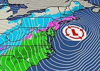
The heat given off by the ocean is like fuel for the storm. Barometric pressure can drop rapidly causing the winds to increase rapidly. This is the reason nor’easter grow very strong and wreak havoc on the east coast. The warm moist air is extremely plentiful off the southeast coast. This energy feeds into the developing storm via the warm sector of the low. The warm air then rises as it encounters cooler air to the north. This rising motion causes condensation (clouds) to occur which then leads to precipitation. The condensation process actually creates heat (latent heat) and this process further adds fuel to the storm ís energy. Upper level winds and conditions also add to the intensification process. If you look at a surface analysis map with the isobars, which are lines that connect equal barometric pressure, you will see that the lines are packed closely together in a storm that is bombing out. This indicates that the pressure gradient is steep and that the winds are strong. These storms sometimes produce hurricane force winds and they cover a large piece of real estate, extending farther than even the largest hurricanes.
So, now that Winter Storm Juno is “bombing out,” it is swinging back toward the Northeast like a winter hurricane. Some forecasters are predicting 30″ of snow and winds exceeding 40 knots.
Time to prepare for the storm — food, water, flashlights, wine, beer, and rum. I think that we are ready. Hope everyone stays safe and warm in Juno’s path.
Since yesterday, weather.gov has shown off shore hurricane force winds from Long Island to the Maine-New Hampshire boarder, still there today too at 2pm Est.
NYC GOV reports the highest recorded snowfall at 26.9 inches in February 2006.
We’ll see if they break it.
And not cheat by measuring drifts.
If it hit here, the building has a gas hotwater boiler, but the generator only powers emergency lighting and elevators.
That means to stove and no microwave.
Luckily we’re on the sme power mains as city hall and the police dept. in 8 years, its never been out for more the 45 minutes to one hour.
New storm maps on ABC, a bit different from yesterday’s
abcnews.go.com/US/thousands-flights-canceled-ahead-major-winter-storm/story?id=28481024
No New York this isn’t the worst storm, yet anyway.
Try 1888.
Remembering the Storm That Shut Down New York City
Jan 26, 2015, 9:08 AM ET
More than 125 years later, the Great Blizzard of 1888’s legacy still resonates.
The storm is drawing new attention as the East Coast prepares today for a devastating winter onslaught, with 12 to 18 inches of snow possible in New York City in the coming days.
The city has been hit hard before -– including March 11 to 14, 1888. The blizzard remains one of the worst storms in U.S. history — dumping 50 inches of snow in some areas, according to the National Weather Service, with drifts up to 50 feet high reported and residents from Maryland to Maine impacted.
abcnews.go.com/US/remembering-storm-shut-york-city/story?id=28484263
The Great Storm of 1888 made the first (I think) issue of The National Geographic Magazine.