
Photo: British Royal National Lifeboat
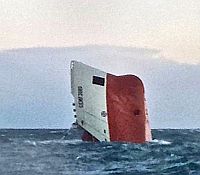
As we posted on Sunday, the passengers on the NorthLink ferry Hrossey, crossing Pentland Firth, off Scotland, saw a grim sight out the ferry windows — the bow of the cement carrier Cemfjord floating vertically in the water. The ship was loaded with 2,000 tonnes of cement and had sailed from Aalborg in Denmark bound for Runcorn in Cheshire. Eight crew, seven Poles and one Filipino, are missing and are presumed to have drowned when the ship sank.
There are now serious questions as to whether the ship should ever have been allowed to sail. The Cemford sailed with several serious mechanical deficiencies. There was a serious problem with her bilge pumps. Though managed by the German company, Brise of Hamburg, the ship was registered is Cyprus. The Cypriot authorities required the ship to carry two portable pumps on board the ship, presumably to supplement the ship’s bilge pumps, and limited the ship’s operation to 150 miles from the coast. The ship also had a faulty lifeboat davit, so an additional life raft was required to be carried. One life raft was spotted after the ship sank, but no one was aboard.
Restricting the operation of the ship to coastwise service may suggest that the Cypriot authorities were concerned about the ability of the ship to handle severe conditions offshore. Tragically, the Pentland Fith where the ship sank, is notorious for strong currents and steep waves, particularly when strong northwest winds oppose the tidal currents. Rachel Carson wrote of the the dangers of the Pentland Firth:
“In this confused, tumbling, and bursting sea, vessels often become entirely unmanageable and sometimes founder, while others have been tossed about for days together,” says the British Islands Pilot. Such dangerous waters have been personified in many parts of the world by names, which are handed down through generations of seafaring men. As in the time of our grandfathers and of their grandfathers, the Bore of Duncansby and the Merry Men of Mey rage at opposite ends of the Pentland Firth. The sailing directions for the Firth in the North Sea Pilot for 1875 contained a warning to mariners that is repeated verbatim in the British Islands Pilot in use today: “Before entering the Pentland Firth all vessels should be prepared to batten down, and the hatches of small vessels ought to be secured even in the finest weather, as it is difficult to see what may be going on in the distance, and the transition from smooth water to a broken sea is so sudden that no time is given for making arrangements.” Both roosts are caused by the meeting of swells from the open ocean with opposing tidal currents, so the Bore of Duncansby, at the east end of the Firth, is to be feared when there is an easterly swell and a flood tide, and the Merry Men of Mey, at the west end, stage their revelries with a westerly swell and an ebb tide. Then, according to the Pilot, “a sea is raised which cannot be imagined by those who have never experienced it.”
If the Cemfjord was forbidden from sailing 150 miles from the coast she should never have been allowed to sail the Pentland Firth in the winter.
Thanks to Dirk J. Bal and Phil Leon for contributing to the post.
I pity those men and what they must have thought when the world around them turned. It truly is u fathomable to believe that there were the types of conditions placed on this vessel prior to sailing. Who if anyone will be held accountable for this tragedy.
Shipowners greed = rust bucket death ship = men’s lifes! Who indeed will be held responsible? Likely no one.
The odd thing is that if you look at the ship’s AIS track, you can see that she proceeded at pretty much constant speed and apparently unperturbed heading until *blip*, she vanishes. Only in the 6 minutes of AIS updates are there any symptoms of trouble, as her speed fell noticeably. If flooding befell the ship that quickly then even a perfect bilge system probably wouldn’t have been much use.
The folks at Gcaptain seem to think it’s another liquefaction/shift incident.
From my reading of the AIS record it looked as if she was making at least 10 knots as she picked up the west going ebb tide in the channel north of the Pentland Skerries and gradually lost speed until the last record of 5 knots which was north of the island of Stroma where the firth widens out into the Atlantic – the area where the tidal current was holding back the swell and wind waves from the west. Add to that the funnelling effect on the wind of the 600 foot cliffs of Hoy to the north west and this was truly the wrong place at the wrong time.
Very interesting. Thanks.