
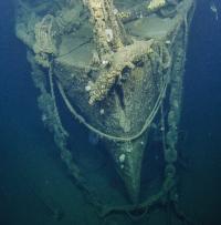
Bow of USS Independence, seen for the first time after 65 years. Photo: Ocean Exploration Trust
On Veteran’s Day, a post about a veteran ship, USS Independence, a light aircraft carrier that served in key battles at the Pacific toward the end of World War II. After the war, she was used as a target in atomic bomb tests in Bikini Atoll. In 1951, the ship was scuttled near the Farallon Islands off the coast of California. Now, 65 years later, an expedition, led by Robert Ballard and partnered with the Ocean Exploration Trust and the National Oceanic and Atmospheric Administration (NOAA), has returned to the sunken ship.
USS Independence was built in New Jersey and commissioned in 1943, the first of a new class of carriers designed from converted cruiser hulls. She took part in the attacks on Rabaul and Tarawa before being torpedoed by Japanese aircraft. She returned to the conflict in time to launch strikes against targets in Luzon and Okinawa and to serve as part of the carrier group that sank the remnants of the Japanese Mobile Fleet in the Battle of Leyte Gulf and in the Surigao Strait. With Japan’s surrender, USS Independence brought US troops home as part of Operation Magic Carpet. USS Independence received eight battle stars for her service in the war, and was recognized for sinking Japanese the battleship, Musashi, during the Battle of the Philippines.
In 1946, USS Independence was used as a target vessel for the Operation Crossroads atomic bomb tests at the Bikini Atoll in the Pacific. The ship was anchored within one-half-mile of ground zero and was damaged but survived the blast. The ship’s hull, however, was highly radioactive.
USS Independence was later moved to Pearl Harbor and then San Francisco and was finally scuttled near the Farallon Islands off the coast of California on 29 January 1951.
From the Rhode Island University’s Inner Space Center website: Sixty-four years later, in March of 2015, NOAA’s Office of National Marine Sanctuaries (ONMS), Ocean Exploration and Research (OER), and the Naval History and Heritage Command (NHHC) positively identified the USS Independence wreck site. Scientists were able to construct a 3-D sonar image of the wreck using autonomous underwater vehicle (AUV), Echo Ranger. They found the Independence surprisingly intact, with a possible plane in the forward aircraft elevator hatch opening.
On August 22, 2016, Dr. Robert Ballard and the crew of the E/V Nautilus began a series of exploratory dives on the Independence wreck using remotely operated vehicles (ROVs), Hercules and Argus. These USS Independence dives are part of Nautilus‘s expedition to explore the Greater Farallones National Marine Sanctuary and Monterey Bay National Marine Sanctuary off the coast of California. Using teleprescence technologies, viewers around the world were able to participate in the rediscovery of this proud ship.
For more information on the USS Independence, including eyewitness accounts and photos, check out the Naval Historical Foundation’s page, Rediscovering USS Independence or visit the Nautilus Live website.
USS Independence: An ‘Operation Crossroads’ Target (1941-1951) | Nautilus Live
Ah! pardon me but I think that’s BIKINI not Bimini.
Good Watch
Thank you. I am a fumbled fingered idiot, at times.
Still the best nautical blog though !!
Good Watch