
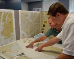
 When I bought my new-to-me old boat, I bought several booklets of paper charts covering the waters from the Chesapeake to Maine. Over the last few years, I have never used them. Never, not once. Instead, I have chart plotters on a laptop, two tablets, and my phone. My paper charts have stayed buried at the bottom of the cabinet beneath the chart table. Nevertheless, I still had mixed feelings when I read that the National Oceanic and Atmospheric Administration (NOAA ) is phasing out the production of traditional paper nautical charts.
NOAA announced in the Federal Register of November 15, 2019, that it is initiating a five-year process to end all traditional paper nautical chart production and is seeking the public’s feedback on the program.
NOAA is not getting out of the chart business. It is simply moving to fully electronic navigational charts (ENCs). The good news is that NOAA is working to improve the ENCs that they provide. From their announcement:
NOAA is in the midst of a multi-year program to improve its ENC coverage by replacing over 1,200 irregularly shaped ENC cells, compiled in over 130 different scales, with a standard gridded layout of ENCs, compiled in just a dozen standard scales. This will increase the number of ENC cells to about 9,000 and significantly improve the level of detail and consistency among ENCs. More information about improvements being made is in Transforming the NOAA ENC®.
Better ECNs are all well and good but shouldn’t we have paper backups? NOAA will, for example, no longer be providing, among other chart services, print-on-demand (POD) paper nautical charts or full-size chart PDFs.
NOAA has a plan to allow customized paper chart products based on ENC data. They are developing a NOAA Custom Chart (NCC) prototype from which “Users may define the scale and paper size of custom-made nautical charts centered on a position of their choosing. NCC then creates a geospatially referenced Portable Document Format (GeoPDF) image of a nautical chart. Chart notes and other marginalia are placed on a separate PDF page. Users may then download, view, and print the output. NCC is an easy way to create a paper or digital backup for electronic chart systems or other Global Positioning System (GPS) enabled chart displays.”
As I lack a large flatbed printer, the statement that “NCC is an easy way to create a paper or digital backup” seems arguable. On the other hand, given that I have never used my current paper charts for anything other than providing peace of mind, perhaps digital backups will be enough.
Sorry, but this is old news on the great lakes.
They got rid of them several years ago, unfortunately.
With GPS, I guess they didn’t feel the need.
Thankfully they stopped issueing weather reports in all CAPS, I hated that.
Then again my GPS burned through batteries even when off, what an idiot design.
It is a solas requirement to either have paper charts or two separate ECDIS systems set up with approved hardware. This may not be practical for some small operators. I got into the habit of always having the paper chart of the area I’m navigating out on the table. I like it because it gives a larger perspective. I also depend almost exclusively on the electronic chart but I still like to have the paper one out for reference.
IMO does allows the operation of ECDIS in RCDS mode as a backup. This is essentially digital scans of charts without full ECDIS functionality. Given the relative costs, most ship owners choose to install a second ECDIS system.
This is frightening. All electronic navigational aids are practical BUT… Given the doubtful reliablity of on-board electronics, given a good virus attack by a hostile power and the loss of all satellite connections within the first few seconds of a major conflict, it is folly not to have paper charts, and, if offshore sailing, a sextant, a chronometer and tables on board. These could be just as lifesaving as the mandatory carrying of life rafts.
I have gps on my 22ft catboat, but only use in times of fog etc. My chart book is always out when sailing more than a short distance, and used at home for planning. This is a horrible idea, ok for ships and larger boats with more people on them. Luckily I am older, my old charts will have to last!!Peter.
Exactly!
I failed to mention, NOAA still has charts online, good luck finding what you need.
https://www.charts.noaa.gov/ChartCatalog/MapSelect.html
The only real change is that the traditional raster charts will be going away. The ENC versions will be available in PDF versions and one can only hope that publishers will still publish chart books using the ENC rather than the old raster format. Whether a boater keeps an electronic or a paper backup will be a personal decision. I’d probably have both.