
Image: Global Fishing Watch / Orbcomm / Spire.
On June 5, 2019, the offshore supply boat Princess Janice was operating from a Nigerian oil terminal when suddenly the AIS (Automatic Identification System) an automatic tracking system showed the vessel a continent away, circling above Point Reyes, CA, eventually veering off above Utah. The false AIS reading continued for over two weeks.
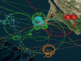
Princess Janice was not the only ship with false AIS data. A total of 12 ships’ AIS positions appeared to be being thousands of miles from their actual position, traveling in circles or ovals, often partially over land. Most of the vessels reported circling positions off the coast of Northern California, though two were shown off Madrid, one to the vicinity of Hong Kong and another to the Chinese city of Shanwei.
The circular or oval tracks of the false AIS readings have been dubbed “crops circles” by the press and were first observed near in December 2019 near oil terminals in China and later near terminals in Iran. The difference is that the previous Chinese and Iranian AIS circles were close to the vessels in question, unlike the recent observations which have been many thousands of miles away.
What is happening? No one really knows. The anomalies were first reported by Sky Truth, an environmental non-profit. Researcher Bjorn Bergman of SkyTruth presented his findings at the annual meeting of the Resilient Navigation and Timing Foundation on the 5th of May. When asked at the briefing if this was the result of GPS spoofing or some fault in the vessels’ AIS system, Bergman replied that he was uncertain.
In the case of the earlier Chinese “crop circles” researchers with Sky Truth and Global Fishing Watch concluded that what they were observing was an actual disruption of the underlying global positioning system (GPS) — or more broadly the Global Navigation Satellite System — and not just a shipboard AIS malfunction. They knew this because other GPS sources in the area, Strava GPS fitness trackers, were also producing rings.
The false AIS positions continue to be present in China. Bergman writes in the Sky Truth blog: A quick recent check of the data showed that this GPS manipulation is ongoing at oil terminals in four of the cities (Shanghai, Dalian, Fuzhou, and Quanzhou) where we had detected it last year. We still don’t know if this manipulation is specifically intended to mask ship traffic or if there is some other reason for disrupting GPS.
Critically, while we could confirm that GPS interference caused the rings of AIS positions on the Chinese coast, we don’t yet know if that is the case with the positions over Point Reyes. An alternative is that this is simply a malfunction affecting the individual ships’ AIS systems. We were able to confirm that the false circling positions over Point Reyes occur in data from all available AIS providers (Orbcomm, Spire, and ExactEarth) and in AIS positions received by both satellites and terrestrial receivers.
But why Point Reyes? Bergman writes: So far it remains a mystery why these circling AIS tracks are appearing specifically at Point Reyes and a few other locations. It’s tempting to speculate that there might be some connection to a major U.S. Coast Guard communication station in Point Reyes which was an important historic location for developing maritime communications technology. While the Coast Guard left the area several years ago, volunteers continue to maintain at Point Reyes the only operational ship-to-shore maritime radio station. Still, it’s unclear why this location would somehow appear on AIS trackers. The fact that individual vessels in many different locations have been affected is puzzling and it’s unknown if any of these examples reflect actual disruptions of the GPS system. However, some studies, such as a yearlong cruise by researchers of the German Aerospace Center which measured instances of GPS interference even during high seas transits, indicate that we may still have a great deal to learn about the true extent of global disruptions to this critical navigation system.
GPS spoofing has been a serious concern for some time. In 2013, we posted about the work of University of Texas Professor Todd Humphreys who demonstrated GPS spoofing by taking over the navigation systems on the 213′ yacht White Rose. More recently, in 2017, at least 20 ships operating in the Black Sea, off the Russian port of Novorossiysk discovered that their GPS located them more than 32 kilometers inland, at Gelendzhik Airport. Western intelligence sources are concerned that the Russians were testing a new form of cyber-warfare.
And now, how, why, and who is causing ghost ships to cruise in circles over Port Reyes and other ports around the globe remains a deeply troubling mystery.
Thanks to Irwin Bryan and Sharon Thimot Shalno for contributing to this post.
China, Iran, Russian or N. Korean.
Our next war.
Sounds like it is more of a radio signal. The oil platform structure is already a broadcasting tower that just needs a signal. If I am reading the article correctly, the errors are happening around the platforms.
Willy, AIS does use radio, both terrestrial and satellite.
And a continuing reason to not rely on a single method of position fixing. Continue to look out the window. Take a radar range or two. Check the depth sounder. Run a rough DR if out of sight of land.
Don’t throw out those old paper charts just yet!