
 A huge cloud of desert dust has blown off the Sahara and is bound across the Atlantic Ocean heading toward the United States. While dust plumes are not uncommon, this plume is exceptionally large and dense with the highest concentration of dust particles observed in 50 to 60 years.
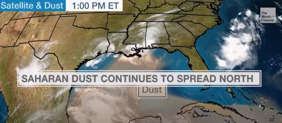
The plume has already turned blue Caribbean skies a hazy brownish gray and is expected to arrive on the US Gulf Coast later this week after traveling 5,000 miles from Africa.
The plume could have a range of impacts on local weather in the South-East. Sunsets and sunrises may look brighter and more vibrant, with orange and red hues showing up more clearly as the dust scatters the sun’s rays.
The dust should also bring drier air which has the benefit that tropical storms and hurricanes in this already busy hurricane season may be temporarily less active while the plume is around.
The Washington Post explains that the dust creates a layer of hot, dry desert air that has largely “capped” the lower atmosphere, putting a lid on thunderstorm development across the tropical Atlantic. The hot air prevents pockets of air below from rising, while the dry air works to shred any clouds that do manage to tower. Essentially, the atmosphere is squelching any attempts at storm genesis before it can even occur.
The bad news is that the effect is likely to be temporary. Forecasts are still projecting an above-average Atlantic hurricane season for 2020.
May have already hit Cleveland, two mornings ago, the Sun rise was a bright cherry red, it’s usually orange.
We in the UK get sandy rain at least once a year, usually just after I have washed our cars.