
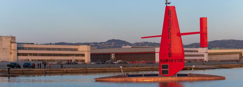
 Saildrone‘s new 72’ long Surveyor is described as the world’s most advanced uncrewed surface vehicle (USV), equipped for high-resolution mapping of the ocean seafloor.
The Saildrone Surveyor is a step up from the 22′ long Saildrone Explorer, yet both combine wind and solar power to perform autonomous long-range data collection in the harshest of ocean environments. The Saildrone wing technology enables a mission duration of up to 12 months, without the need to return to land for maintenance or refueling. The 22′ Saildrone Explorer travels at an average speed of two to three knots and can reach top speeds above eight knots; the 72′ Saildrone Surveyor travels at ten knots.
As described on the Saildrone website: The Surveyor carries a sophisticated array of acoustic instruments for both shallow and deep-water ocean mapping; the Kongsberg EM 304 multibeam echo sounder is capable of mapping the seafloor down to 7,000 meters below the surface. The Surveyor also carries two state-of-the-art Acoustic Doppler Current Profilers (ADCPs), the Teledyne Pinnacle 45 kHz ADCP and the Simrad EC150-3C ADCP, to measure ocean currents and understand what is in the water column. The Surveyor is also equipped with the Simrad EK80 echo sounder for fish stock assessments.
Like the Explorer, the Saildrone Surveyor is uncrewed and uses renewable solar energy to power its robust sensor suite; the Surveyor delivers an equivalent survey capability, but at a fraction of the cost and carbon footprint of a traditional survey ship and without putting human health and safety at risk.
“The launch of the Surveyor is a huge step up, not just for Saildrone’s data services but for the capabilities of uncrewed systems in our oceans,” said Richard Jenkins, founder & CEO of Saildrone. “For the first time, a scalable solution now exists to map our planet within our lifetime, at an affordable cost.”
Saildrone Surveyor Launch from Saildrone Inc. on Vimeo.
Thanks to Dexter Donham for contributing to this post
Revelations? Woe is man when he can measure the foundations of the Earth.
Forward motion being wind assisted (the other force being current) must be quite inhibiting as to where it can actually safely go. Uncharted areas for increasing navigation would predominantly be coastal or sometimes ice covered like North Alaska. So it probably won’t be used there. However there are vast areas of open ocean where no measurements have been made because it has not been necessary, far away from trade routes etc.
So it will be collecting data, much of it of no relevance but maybe it will find new fish stocks for the Chinese to plunder.