
 For several years now we have followed the progress of the autonomous sailing drones developed by the aptly name firm, Saildrone, in oceanographic service in the Pacific and Bering Seas. In January, we posted about Saildrone’s new 72’ long Surveyor, which is described as the world’s most advanced uncrewed surface vehicle (USV), equipped for high-resolution mapping of the ocean seafloor.
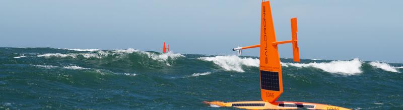
Now, Saildrone is broadening its mission and geography to study the Atlantic’s Gulf Stream. Funded in part by a grant of roughly $1 million from Google.org, the 12-month mission is expected to yield insights into the impact of the Gulf Stream on weather forecasting and global carbon models. Saildrone will be launching a half dozen of its 23-foot Explorer model drones to roam the North Atlantic.
As described on the Saildrone website:
Historically, fewer than a handful of ship-based studies in the Gulf Stream have provided only week-long snapshots of air-sea exchange due to the treacherous conditions, especially in winter. Free-floating platforms that might gather data tend to get quickly ejected from the Gulf Stream. Attempts to use moored instruments to collect measurements have also been made, but strong currents and winds have led to only short-duration successes.
Saildrone USVs are highly maneuverable, wind and solar-powered vehicles designed for long-range data collection missions. The Saildrone fleet has logged more than 10,000 days at sea in some of the most extreme weather conditions on the planet. The impressive capabilities of Saildrone’s autonomous vehicles have been proven in numerous operational missions for science, ocean mapping, and maritime security, covering over 500,000 nautical miles from the Arctic to the Southern Ocean.