
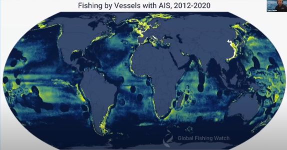
 Way back in 2015, we posted – Can Big Data Stop Overfishing? Will Google’s Global Fishing Watch Succeed? The post described a new project in which Google partnered with SkyTruth and Oceana to produce a tool to track global fishing activity, in hopes of identifying and cracking down on illegal fishing. Known as Global Fishing Watch (GFW) the interactive web tool uses satellite data to provide detailed vessel tracking and aims to harness the power of citizen engagement to tackle the issue of overfishing.
Now, almost a decade later, the answer to our original question “Will Google’s Global Fishing Watch succeed?” is a muddled “yes” and “no”.
The good news is that GFW has succeeded in using artificial intelligence algorithms (AI) to identify vessels in satellite images of the oceans.
The bad news is that an analysis of the data reveals that up to three-quarters of large fishing boats and about a quarter of energy and transport ships are “dark vessels” that do not publicly share their location, as required by international regulations.
The analysis was performed by Global Fishing Watch, and its findings were published in the journal Nature. “We had an idea that we were missing a big chunk of the activity happening in the ocean, but we didn’t know how much. It’s a lot more than we imagined,” Fernando Paolo, a machine learning engineer at GFW, told The Conversation.
The researchers used satellite images, including radar images that can reveal the presence of vessels regardless of cloud cover or darkness, that were taken between 2017 and 2021. The images covered the coastal regions where most large-scale fishing and ocean-based industrial activities occur. As part of the research, several AI algorithms were trained to detect and categorize the various vessels and offshore structures identified within the data.
The enormous global map of vessels was compared with a database of ships that publicly broadcast their location using automatic identification systems or AIS devices that automatically broadcast their identity, position, course and speed. The researchers found that up to 75% of vessels were not using their AIS systems. Such avoidance is not necessarily prohibited, but the fact they’re not being used indicates that some of the vessels may be engaged in illegal fishing or other illicit activities.
The research revealed some alarming discrepancies between publicly available AIS data and the reality of shipping activity in coastal regions. For instance, though AIS data suggests that Asia and Europe have roughly comparable fishing activity, GFW’s analysis shows that’s not the case.
Although the researchers believe their AI algorithms are reliable, they admit that publicly available satellite images lack the resolution to detect smaller fishing vessels shorter than 20 meters in length. Even so, they argue that satellite-based monitoring can improve efforts to safeguard protected marine areas and unregulated areas of the ocean.
Thanks to Alaric Bond for contributing to this post.
Although the researchers believe their AI algorithms are reliable,
The 700 sacked UK Postmasters will take comfort in this declaration
https://abcnews.go.com/International/wireStory/police-probe-uk-post-office-accusing-700-employees-106155626